The Mount Stephen Route
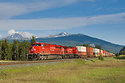
An eastbound stack train negoiates the last of the 2.2% on the climb thru Partridge above the Upper Spiral Tunnel.
Mount Stephen pierces the blue sky at a lofty 10495 feet. The mountain rises 6374 feet almost straight up above the valley floor and the creek change location of Field, BC covered in the shadow (center photo).
The highway in the lower center of the photo (below the train) is where the original Big Hill was located. This was a 4.5% temporary line that operated from 1884 to 1909. The route included safety tracks, that caught more than one runaway train.
The original construction plan for the Kicking Horse Pass was the Mount Stephen Route. This would have extended the track from the location of Partridge Siding along the cliff face of Mount Stephen, then high above Field to a place near Kicking Horse canyon on a continuous 2.2% grade. Instead a cheaper solution was later chosen. A pair of Spiral Tunnels underground would lower the route down to the valley floor. It is easy to visualize in this photo there the Mount Stephen route would have gone by tracing a line from the last visible curve on the upper level of track, then going along the face of Mount Stephen.